
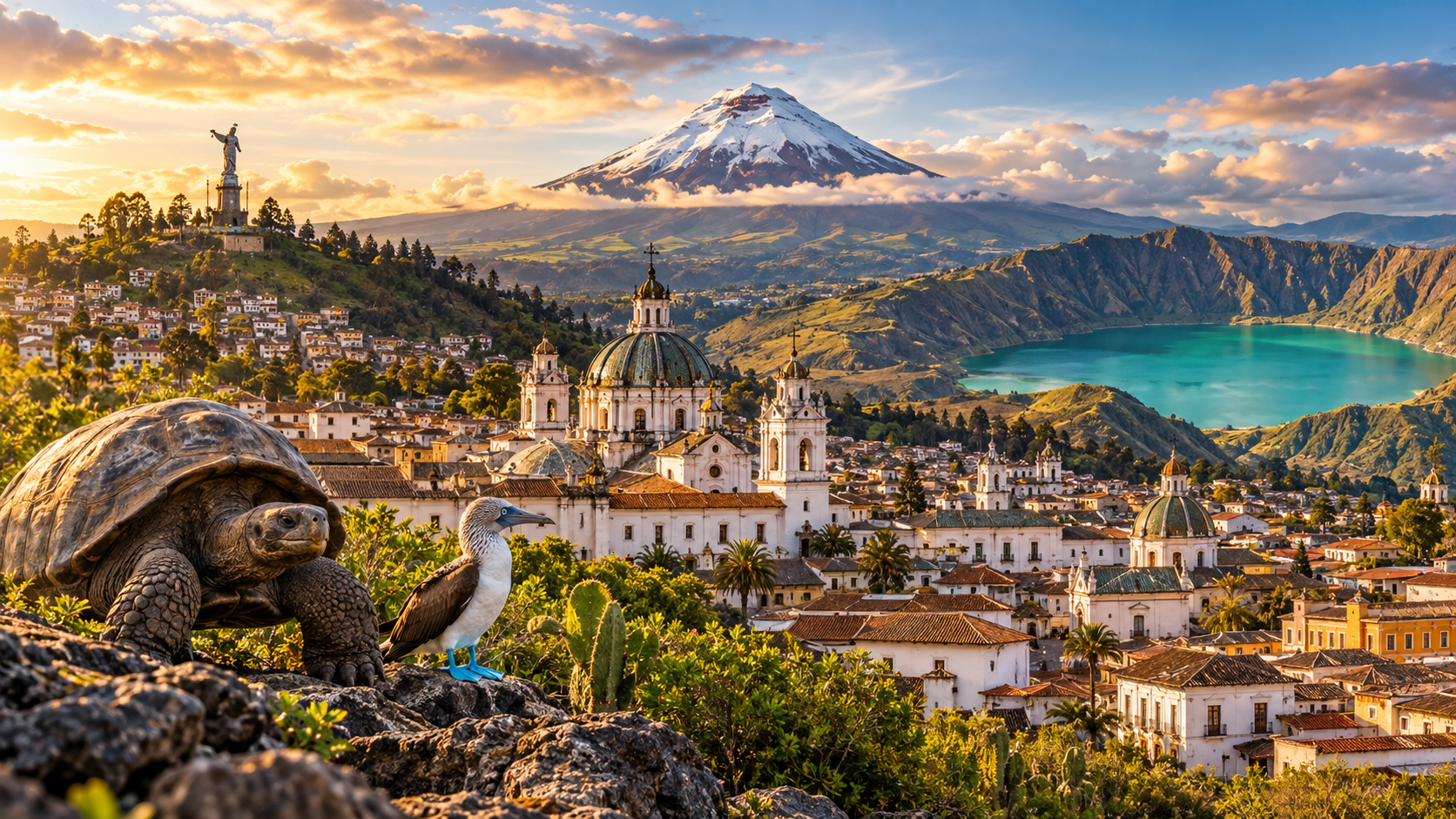
Ask someone in the United States what they know about Ecuador and there is a decent chance the answer begins with giant tortoises.
Fair enough. The Galápagos Islands are extraordinary.
But mainland Ecuador is doing a lot more than waiting for travelers to board a flight to the islands.
This relatively compact South American country packs colonial cities, snowcapped volcanoes, crater lakes, cloud forests, Amazon rainforest, archaeological sites, Pacific beaches and some very serious mountain scenery into an area smaller than many Americans expect.
That is the fun part.
You can wake up in Quito at around 9,350 feet above sea level, spend the next day looking toward Cotopaxi’s volcanic cone, move through green Andean valleys, then eventually drop toward humid jungle or the Pacific coast.
The distances on the map do not look dramatic.
The changes in landscape definitely are.
For travelers searching for landmarks in Ecuador, the hardest part is not finding places worth seeing. It is deciding how many completely different versions of Ecuador can reasonably fit into one trip.
Quito is the best place to start
Ecuador’s capital sits high in the Andes, surrounded by mountains and volcanoes.
Even before you see a landmark, the geography gets your attention.
The city stretches through a long valley rather than spreading neatly in every direction. Hills rise around neighborhoods. Clouds move quickly. On clear days, distant peaks appear between buildings as if somebody added them to the skyline afterward.
Quito’s historic center is one of the country’s most important landmarks in its own right.
UNESCO added the City of Quito to the World Heritage List in 1978, making it one of the first places inscribed when the list was still new.
The old center preserves a remarkable concentration of churches, plazas, monasteries and colonial-era architecture.
And unlike a historic district that feels frozen for tourists, central Quito still has plenty of everyday movement.
People commute through it. Shops open. Food vendors work. Church bells ring.
History is not sitting behind glass.
La Compañía is the church that surprises almost everyone
From outside, the Church of La Compañía de Jesús is impressive.
Then you walk inside.
Gold seems to be everywhere.
The interior is one of Quito’s most celebrated examples of Baroque religious art, with elaborate carved surfaces, gilded decoration and a visual density that takes a moment to process.
It is not minimalist.
Not even slightly.
If you visit several churches in the historic center, La Compañía is usually the one people remember most clearly afterward.
San Francisco feels like a city inside the city
Plaza de San Francisco and the large religious complex beside it form another major stop in old Quito.
The church and convent developed over centuries and represent one of the historic center’s most important architectural ensembles.
The broad plaza outside is useful too.
After walking through narrow streets and ornate interiors, suddenly you have space.
Sit for a minute.
Quito’s altitude has a way of reminding enthusiastic travelers that they are not at sea level.
The Middle of the World is fun, even with a geography footnote
North of central Quito sits the famous Mitad del Mundo monument, created around Ecuador’s relationship with the equator.
This is where people take the classic photo with one foot supposedly in each hemisphere.
There is a nuance.
Modern GPS measurements place the exact equatorial line a little away from the monumental line traditionally marked at the site.
Does that ruin the experience?
Not really.
The larger point remains interesting: Ecuador literally takes its name from the equator, and the country sits directly across that global dividing line.
Just do not return home claiming your left shoe was scientifically proven to be in the Southern Hemisphere while the right one was definitely in the Northern Hemisphere.
| Landmark | Region | Best Known For |
|---|---|---|
| Historic Quito | Andes | Colonial architecture, churches and mountain setting |
| Cotopaxi | Andes | High volcanic cone and páramo landscapes |
| Quilotoa | Andes | Turquoise crater lake |
| Cuenca | Southern Andes | Historic center, churches and relaxed urban life |
| Ingapirca | Southern Andes | Important Inca and Cañari archaeological site |
| Galápagos Islands | Pacific | Endemic wildlife and volcanic landscapes |
| Sangay National Park | Central Ecuador | Volcanoes, páramo and rainforest ecosystems |
Cotopaxi looks almost too symmetrical
If you asked someone to draw a volcano from memory, there is a good chance they would accidentally draw something resembling Cotopaxi.
Its high cone rises above the Andean landscape with a snow- and ice-covered summit when conditions allow.
Cotopaxi National Park lies south of Quito and makes one of the most popular mountain trips from the capital.
The volcano reaches about 19,347 feet above sea level, so this is not casual hiking elevation.
Even visitors who stay far below the summit feel the altitude.
The surrounding páramo landscape is part of the experience: open high-altitude grasslands, cold wind, volcanic terrain and huge skies.
You do not need to attempt a summit to appreciate Cotopaxi.
Actually, most travelers should not.
Simply being in the national park and seeing the volcano from lower elevations can be enough.
Quilotoa may be Ecuador’s most photogenic hole in the ground
That description sounds rude until you remember what a crater lake is.
Quilotoa formed inside a volcanic caldera high in the Andes. Its water can appear turquoise, blue or green depending on light and conditions.
The first view from the crater rim is the moment everyone comes for.
Then gravity gets involved.
A trail descends toward the lake, which seems simple on the way down.
Coming back up at high elevation is another matter.
This is where travelers discover that “only a few kilometers” means very little when most of the return trip points uphill and the air contains noticeably less oxygen than you’re used to.
If you are not acclimatized, take it slowly.
The Quilotoa Loop is bigger than the lake
The broader Quilotoa region includes Andean villages, farms, mountain scenery and hiking routes sometimes grouped under the name Quilotoa Loop.
Travelers can move between villages rather than treating the crater as a two-hour roadside attraction.
This adds something important.
The Ecuadorian Andes are not empty mountains designed for hikers.
People farm here. Indigenous communities live here. Markets, local transport and village life are all part of the landscape.
If your schedule allows, slowing down gives you a much better sense of the region.
Cuenca feels different from Quito almost immediately
Cuenca sits in Ecuador’s southern Andes and has one of the country’s most appealing historic centers.
It is smaller and generally feels more relaxed than Quito.
Colonial-era streets, plazas, churches, rivers and low-rise buildings create a city where walking feels natural.
The Historic Centre of Santa Ana de los Ríos de Cuenca became a UNESCO World Heritage property in 1999.
Its urban plan reflects Spanish colonial planning while also preserving earlier Andean influences and later architectural layers.
One of the easiest landmarks to recognize is the New Cathedral, formally known as the Cathedral of the Immaculate Conception, with its large blue domes.
You see them repeatedly while walking around town.
They work almost like navigation.
Cuenca is also where the “Panama hat” story gets corrected
You know the famous Panama hat?
It is strongly associated with Ecuador.
The traditional finely woven straw hats known as toquilla hats are made in Ecuador, including in and around Cuenca and other regions.
The misleading international name became popular because the hats were shipped and worn through Panama, particularly around the era of canal construction.
So yes, one of the most famous things called “Panama” is actually Ecuadorian.
Travel is full of branding problems.
Ingapirca tells a story that is not only Inca
Ingapirca is Ecuador’s best-known archaeological complex associated with the Inca period.
But calling it simply an “Inca ruin” leaves out an important part of the story.
The site also reflects the Cañari people who lived in the region before Inca expansion.
The architecture shows evidence of different cultural traditions and the political changes that shaped the Andes before Spanish colonization.
The Temple of the Sun is the most recognizable structure, built with carefully fitted stonework.
The highland setting makes the site feel even more dramatic.
Bring layers.
The Andes are very good at producing four moods of weather before lunch.
Baños is less a landmark and more an outdoor playground
Baños de Agua Santa sits where the Andes begin dropping toward Ecuador’s Amazon basin.
The town is surrounded by steep green terrain and waterfalls, with the Tungurahua volcano nearby.
Travelers come for hot springs, biking, hiking, canyon activities and the famous waterfall route toward Puyo.
The landmark everybody photographs is probably Pailón del Diablo, or Devil’s Cauldron, a powerful waterfall reached through a developed trail system.
Expect water.
Not “maybe a light mist” water.
Actual waterproof-jacket territory.
What are the must-see Andean landmarks?
If your trip is mostly focused on the mountains, these places make a strong backbone:
- Quito’s historic center for architecture and urban history;
- Cotopaxi National Park for classic volcanic scenery;
- Quilotoa for its crater lake and highland villages;
- Cuenca for a slower historic-city experience;
- Ingapirca for archaeology and pre-Columbian history;
- Baños for waterfalls and outdoor activities.
Do not attempt all of them in four days.
Your vacation is not a delivery route.
The Galápagos are famous because they genuinely are unusual
Now we get to the giant tortoises.
The Galápagos Islands sit about 620 miles off Ecuador’s mainland in the Pacific Ocean.
The archipelago became Ecuador’s first natural UNESCO World Heritage property in 1978 and remains one of the planet’s most famous wildlife destinations.
The islands are volcanic and geologically young.
Their isolation allowed plants and animals to develop in unusual ways, producing high levels of endemism.
Giant tortoises, marine iguanas, land iguanas, sea lions and multiple species of finches are among the animals travelers associate with the islands.
The wildlife often behaves differently around humans than animals do in heavily hunted or disturbed environments.
That does not mean you should walk up and hug a sea lion.
Please don’t.
The Galápagos are not one island
This sounds obvious but affects planning a lot.
The archipelago contains multiple islands, and different visitor sites offer different landscapes and wildlife.
Santa Cruz is one of the main tourism hubs and gives access to Puerto Ayora and giant tortoise areas in the highlands.
San Cristóbal is another major inhabited island and is particularly associated with sea lions.
Isabela is the largest island and feels more spread out and volcanic.
You can explore the Galápagos through land-based stays, organized excursions or cruise-style itineraries.
Each approach has tradeoffs.
Cruises may reach more remote sites. Land-based travel gives you more independence and can fit different budgets.
Galápagos rules are there for a reason
The islands are a protected ecosystem, not a giant open-air petting zoo.
Follow park rules and guides carefully.
- Keep the required distance from wildlife.
- Stay on marked paths and visitor areas.
- Do not feed or touch animals.
- Avoid bringing prohibited biological materials between islands or from the mainland.
- Follow instructions for cleaning footwear or equipment when required.
- Never remove shells, rocks, plants or other natural material.
The entire point of visiting is seeing an ecosystem that still functions unusually well.
Do not become the reason it functions a little worse.
Sangay National Park is Ecuador turned up to maximum difficulty
Sangay National Park is less famous with casual tourists than the Galápagos or Cotopaxi, but ecologically it is remarkable.
The UNESCO-listed park stretches across a huge elevation range and contains everything from tropical rainforest to high-altitude páramo and glacial environments.
Sangay itself is one of Ecuador’s active volcanoes.
The park’s remoteness helped protect species such as the mountain tapir and Andean condor.
This is not necessarily the landmark for a traveler who wants to step off a tour bus, take a photo and be back at the hotel by lunch.
Access and activities require more planning.
But as a symbol of Ecuador’s biodiversity, Sangay is hard to beat.
Chimborazo changes the usual “highest mountain” conversation
Chimborazo is Ecuador’s highest mountain, reaching more than 20,500 feet above sea level.
But there is a more fun fact.
Because Earth bulges around the equator, Chimborazo’s summit is the point on Earth’s surface farthest from the planet’s center.
Mount Everest is still higher above sea level.
So nobody needs to rewrite geography textbooks.
But Chimborazo gets a very specific record.
The surrounding wildlife reserve offers high-altitude landscapes where visitors may see vicuñas.
Again, altitude matters.
Even a short walk can feel oddly difficult if you’ve just arrived from Miami.
The Amazon is not one landmark, but it belongs on the list
Eastern Ecuador drops into the Amazon basin.
This part of the country replaces dry high-altitude air with humidity, rivers, dense forest and a completely different soundscape.
Yasuní National Park is one of the best-known protected areas and is celebrated for extraordinary biodiversity.
Elsewhere, travelers can reach Amazon lodges and river-based excursions through gateways such as Tena or Coca.
The experience is not about one monument.
It is about the ecosystem.
Birds, insects, monkeys, rivers, giant trees and night sounds become the landmarks.
And yes, bug spray suddenly becomes more important than the camera lens you researched for six weeks.
Ecuador’s Pacific coast deserves more attention
International tourism often concentrates on the Andes and Galápagos.
Meanwhile, Ecuador has a long Pacific coastline with fishing towns, beach communities, mangroves and protected areas.
Machalilla National Park is one of the major coastal destinations and includes beaches, dry forest and marine environments.
Isla de la Plata, reached from the coast, is sometimes casually nicknamed a “poor man’s Galápagos.”
That nickname is not especially useful.
It is its own place.
The island supports seabirds and seasonal wildlife viewing, while nearby coastal waters are associated with humpback whale migration during part of the year.
Go because the Pacific coast is interesting, not because you’re trying to recreate another destination cheaply.
Qhapaq Ñan reminds you that borders came later
The Qhapaq Ñan, or Andean Road System, is a vast pre-Hispanic network extending across several modern South American countries, including Ecuador.
The UNESCO-listed system linked communities across enormous distances and difficult Andean terrain.
Sections of ancient road, archaeological sites and cultural landscapes remain throughout the Andes.
It changes how you think about mountain geography.
The Andes can look like barriers on a map.
For centuries, people built systems that turned them into routes.
How should you plan a first Ecuador trip?
Ecuador looks small.
Do not let that trick you into rushing.
Mountain roads can be slow. Altitude can require adjustment. Flights to the Galápagos add a completely separate travel segment.
A realistic trip depends on how many regions you want to mix.
| Trip Length | Realistic Focus | What to Avoid |
|---|---|---|
| 5-7 days | Quito + Cotopaxi + Quilotoa, or one focused region | Trying to add Galápagos and Amazon |
| 10 days | Andes + Cuenca/Baños or short Galápagos stay | Changing location every night |
| 14 days | Andes + Galápagos or Andes + Amazon + coast | Assuming every transfer is quick |
| 3 weeks | Several mainland regions plus Galápagos | Building a schedule with no rest days |
If Galápagos is the main reason you’re going, protect enough time for it.
If mainland Ecuador interests you just as much, resist treating Quito as nothing more than an airport stop.
What should you pack for Ecuador?
The answer depends on where you’re going because this country does not believe in one weather system.
- Bring layers for Quito, Cotopaxi, Quilotoa and high-altitude Andean areas.
- Pack real sun protection because altitude makes UV exposure easy to underestimate.
- Bring waterproof protection for cloud forest, Amazon and waterfall trips.
- Use sturdy walking shoes for historic streets and mountain trails.
- Pack lighter clothing for the coast, Amazon and Galápagos.
- Carry a reusable water bottle when practical and follow local drinking-water guidance.
You can experience chilly mountain wind and tropical humidity on the same vacation.
Your suitcase will need diplomacy.
When is the best time to see Ecuador’s landmarks?
There is no single perfect season because the country’s regions behave differently.
The Andes have relatively stable temperatures compared with temperate North America, but wetter and drier periods affect hiking and views.
The Amazon stays humid and receives rain throughout the year.
The Pacific coast has its own seasonal cycle.
Galápagos conditions change with ocean currents, influencing water temperatures and wildlife activity.
So planning by landmark works better than asking for “Ecuador weather” as if the whole country shared one forecast.
If clear mountain views matter most, check seasonal patterns for the Andes.
If wildlife is your Galápagos priority, research the species or activity you care about rather than automatically chasing the driest month.
FAQ About Landmarks in Ecuador
What is the most famous landmark in Ecuador?
The Galápagos Islands are probably Ecuador’s most internationally famous natural landmark. On the mainland, Quito’s historic center and Cotopaxi are among the best-known destinations.
How many UNESCO World Heritage Sites does Ecuador have?
As of 2026, Ecuador has five UNESCO World Heritage properties: Quito, the Galápagos Islands, Sangay National Park, the Historic Centre of Cuenca and the multinational Qhapaq Ñan Andean Road System.
Is Cotopaxi worth visiting if you don’t climb mountains?
Yes. Most visitors do not climb to the summit. The national park offers volcanic views, páramo scenery and lower-elevation experiences that still make the trip worthwhile.
Can you visit Quilotoa as a day trip from Quito?
Yes, day trips are common, though the journey takes time. Staying in the region gives you more flexibility and makes it easier to experience nearby villages and hiking routes.
What is Ecuador’s most important archaeological site?
Ingapirca is generally considered the country’s best-known Inca-era archaeological complex. It also reflects earlier Cañari history, so its story is broader than the Inca period alone.
Are the Galápagos close to mainland Ecuador?
No. The islands lie roughly 620 miles, or about 1,000 kilometers, west of mainland Ecuador in the Pacific Ocean. Most visitors fly from mainland Ecuador.
How many days do you need to see Ecuador?
Ten to fourteen days gives first-time visitors a useful mix of regions. Three weeks is much better if you want to combine the Andes, Amazon, coast and Galápagos without rushing constantly.
The Best Landmarks in Ecuador Are Really About the Changes Between Them
Ecuador’s greatest trick is scale.
On a map, it does not look enormous.
Then you travel through it.
Quito is cool, high and surrounded by mountains.
Cotopaxi feels open and exposed under a giant volcanic sky.
Quilotoa drops suddenly into a crater filled with colored water.
Cuenca slows everything down with plazas, rivers and blue cathedral domes.
Baños turns green and steep as the Andes fall toward the Amazon.
Then the forest thickens.
Or you fly west and suddenly marine iguanas are lying on black volcanic rock beside the Pacific.
That is what makes the landmarks in Ecuador more interesting as a group than as a checklist.
They show how much landscape can change in a relatively compact country.
You get Spanish colonial architecture and pre-Columbian archaeological sites.
Volcanoes and jungle.
High-altitude grasslands and tropical coast.
Modern cities and ecosystems where the animals have never heard of your vacation itinerary.
So yes, see the famous places.
Walk through old Quito.
Stand on the rim of Quilotoa.
Look at Cotopaxi when the clouds cooperate.
Visit Cuenca and Ingapirca.
Go to the Galápagos if time and budget allow.
But leave space between the headline attractions.
A mountain road. A village market. A bowl of soup at altitude. A bus ride where the landscape changes completely in an hour.
Those are often the moments that explain Ecuador better than any monument does.
Leave a Reply