
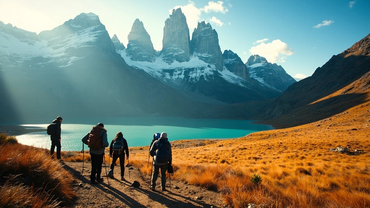
Best Chile tourist attractions to choose for a first trip
Chile packs an unusually wide range of landscapes into one long, narrow country. A first-time visitor can look across Santiago from a hilltop, walk among volcanoes in the Atacama Desert, explore colorful coastal towns, and reach turquoise glacial lakes in Patagonia within the same itinerary. The best chile tourist attractions are not evenly distributed, however. Choosing the wrong combination can mean spending several days in transit instead of enjoying the places that brought you to Chile.
Most travelers need to make three decisions: which regions fit their interests, how much time they can spend moving between them, and whether a demanding outdoor destination is the right choice for their fitness and comfort. This guide compares the leading attractions by landscape, experience, travel demands, and practical appeal. It also explains how to build a manageable route for two weeks, three weeks, or a longer journey through the country.
One useful way to understand an attraction list is to divide it into cities, landscapes, heritage sites, wildlife areas, and coastal destinations. The For additional context, catalog of tourist attractions in Selangor illustrates that basic approach: its categories include historical buildings, museums, nature areas, religious places, shopping centers, and transport hubs. Chile has a different geography and travel rhythm, but the same distinction helps travelers compare places by what they will actually do there.
How to compare Chile’s major destinations
Distance is one of the most important factors in Chile. The country stretches more than 4,000 kilometers from north to south, and the climate changes sharply along the way. Santiago sits in a central valley, while the Atacama lies far to the north. Patagonia is reached by long flights or a multi-day journey overland, and Easter Island sits in the Pacific Ocean with no road connection to the mainland.
| Destination | Main experience | Best time to allocate | Travel consideration |
|---|---|---|---|
| Santiago and central Chile | Architecture, museums, food, vineyards, and easy day trips | 2–4 days | Excellent base with strong transport connections |
| Atacama Desert | Salt flats, volcanoes, high-altitude lagoons, and clear skies | 3–5 days | Long flight north; altitude and remoteness require care |
| Lake District and Chiloé | Lakes, forests, hot springs, coastal villages, and maritime culture | 4–7 days | Longer overland route through changing landscapes |
| Patagonia | Glaciers, granite peaks, steppe, and wilderness hiking | 6–10 days | Seasonal weather and limited transport can affect plans |
| Valparaíso and the central coast | Street art, historic port architecture, seafood, and nearby beaches | 2–3 days | Manageable from Santiago; popular areas can be crowded |
| Easter Island | Volcanic scenery, archaeological sites, and secluded coastlines | 4–6 days | Flights are limited and expensive; an additional island may be required |
Seasonality also depends on the destination. Northern Chile is often considered most pleasant outside the hottest part of the year, while Patagonia’s main outdoor season falls during the southern spring and summer. Conditions can change quickly in mountain areas, so the best plan includes flexibility rather than a rigid daily schedule.
For a short first trip, combining Santiago with the central coast or the Lake District usually produces a more rewarding experience than attempting both Patagonia and the Atacama. Two travelers with strong interests can make different choices: one might prefer architecture and food, while another wants volcanoes, glaciers, and isolated landscapes. The right route depends on what deserves priority in a limited amount of time.
Santiago and central Chile combine culture with easy day trips
Santiago is Chile’s principal city and the most practical starting point for many international visitors. Its center contains historic civic buildings, neighborhood markets, museums, theaters, and restaurants, while surrounding hills provide broad views over the urban basin and the snow-covered Andes. Because the airport and main domestic connections are here, Santiago also works well as a base before beginning a longer journey.
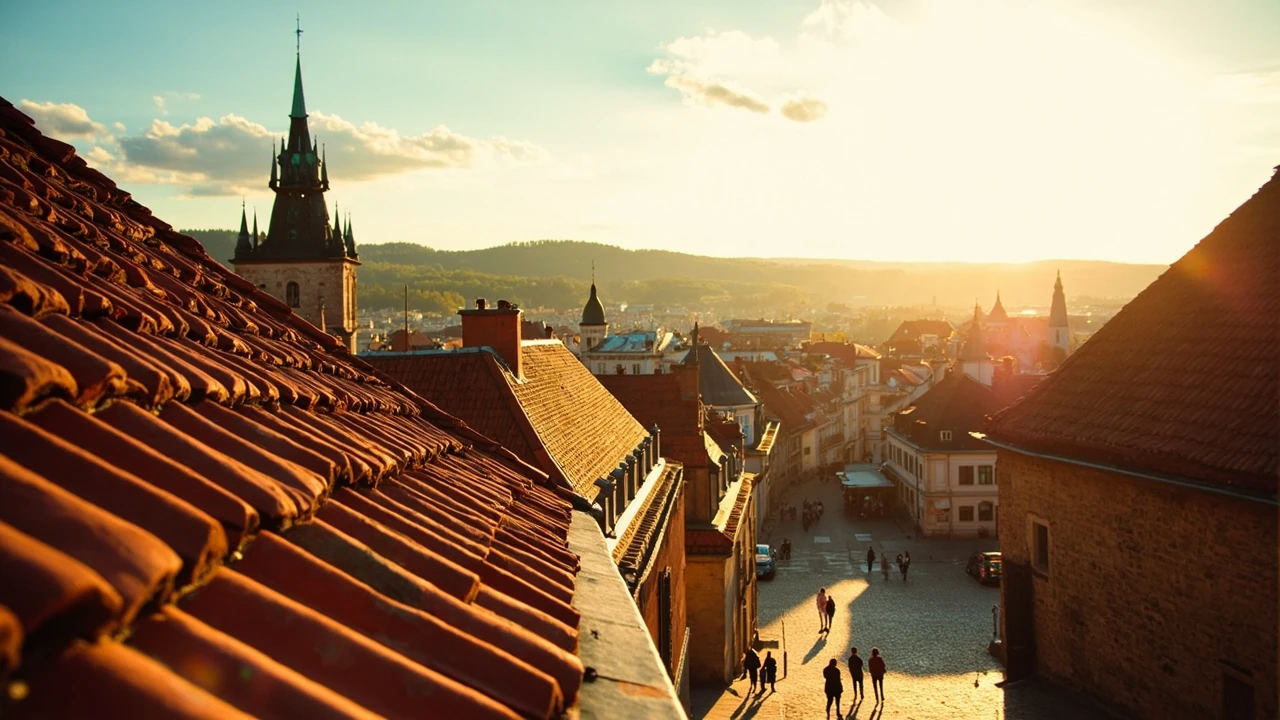
Plaza de Armas and the surrounding historic center are useful for a first walking orientation. The area places major city landmarks within a compact grid and makes it easy to combine a heritage walk with a meal or an afternoon museum visit. The view from Cerro San Cristóbal is a common way to understand Santiago’s geography, but a private rooftop viewpoint or a drive along the same ridge can feel more rewarding for travelers who prefer a less crowded perspective.
La Moneda Palace, the Museum of Memory and Human Rights, and the fine arts complex each deserve time rather than being treated as quick photo stops. Museum schedules, security requirements, and opening arrangements can change, so travelers should check current information before visiting. Allow more time for neighborhoods such as Barrio Lastarria, where courtyards, cafés, galleries, and independent shops create a different experience from the central administrative district.
For scenery without leaving the metropolitan area, the Cajón del Maipo canyon offers a route into rugged mountains east of the city. Alternatively, the Maipo Valley wineries south of Santiago produce memorable day trips for visitors interested in Chilean wine and landscape. These excursions are especially convenient for travelers who do not want to move luggage or cross a major distance.
Other day trips broaden the central itinerary:
- Valparaíso: A coastal city of steep streets, painted walls, historic funiculars, port activity, and views across the bay. It is often combined with Viña del Mar.
- Casa del weakest surviving colonial building in Santiago: A small historic site that can be visited with other downtown landmarks, but one that requires more focused attention than the city’s major museums.
- Andes foothills and ski resorts: Useful for winter scenery, with the best access concentrated in specific valleys and weather-dependent mountain conditions.
- Colchagua Valley: A wine-country alternative south of Santiago, particularly suitable when travelers want a longer countryside stay rather than a short excursion.
Although this particular site name should not be selected without checking local access details, it illustrates why travelers should verify whether a smaller landmark is open and whether it requires a guided visit. A little research prevents a promising stop from consuming several hours without much payoff.
The Atacama Desert delivers stark landscapes and clear skies
The Atacama is Chile’s signature desert destination and one of the clearest reasons travelers plan a northern extension. Its main attractions sit around San Pedro de la Atacama, a town that serves as the base for excursions into salt flats, high-altitude geysers, volcanic terrain, and exceptionally clear skies. The region is dry, sparsely populated, and visually unlike Chile’s forests, lakes, and coastal cities.
El Tatio geysers sit in the mountains north of town. Early morning visits offer a better chance of seeing active geothermal activity because cooler conditions can create more visible steam, although access roads, safety rules, and excursion availability should be checked locally. Laguna del Flamenco and the surrounding highland scenery provide another striking stop, with flamingos present in the lagoon at certain times of year.
The Salar de Atacama is the region’s best-known salt flat. Visitors can walk onto parts of the white surface and look across to volcanic peaks that appear to rise directly from the horizon. The access point known as Flamenco has become popular because it combines a viewpoint, short walks, and lagoon scenery. Crowding can affect the experience, and seasonal water levels change how much of the salt crust is visible.
The Salar de Tara, another salt-flat area, receives fewer visitors and offers a different atmosphere. Its rough access road may require a high-clearance vehicle and careful driving, particularly after rain or near the margin of the lake. The remoteness is part of the attraction, but it also makes a guided tour or an experienced local driver more sensible than an improvised trip.
A catalog of Chile attractions can become repetitive if every salt flat is presented as interchangeable. The better comparison considers landscape, access, crowds, and the time required:
| Atacama feature | What distinguishes it | Typical visit style |
|---|---|---|
| El Tatio | Geothermal fields at very high elevation | Early-morning excursion from San Pedro |
| Salar de Atacama | Expansive salt flat bordered by volcanoes | Half-day to full-day visit |
| Laguna del Flamenco | High-altitude wetland with flamingos | Combined with nearby viewpoints |
| Salar de Tara | Remote salt flat with broad desert views | Guided off-road or high-clearance-vehicle tour |
| Valle de la Luna | Rocky ridges and unusual desert textures | Short stop near San Pedro |
Altitude deserves careful attention. San Pedro itself sits well above sea level, and many excursions go higher. Travelers who feel unwell should slow down, seek medical guidance, and avoid pushing through symptoms. Hydration, sun protection, suitable footwear, and a travel plan that avoids overexertion matter more than attempting every viewpoint.
The Lake District and Chiloé suit travelers who want variety without crossing the country
South of Santiago, the Lake District offers a gentler and more varied route through central Chile. Volcanic peaks rise above lakes and forests, historic towns follow old trade routes, and thermal springs provide a restorative pause after days on the road. This region is a good choice for travelers who want scenery and local culture without committing to Patagonia’s more demanding conditions.
Pucon and Villarrica form a useful base near Lake Villarrica. Boating, kayaking, forest walks, and visits to the volcano and surrounding rural areas give travelers several ways to spend a day. The area is particularly rewarding for outdoor travelers, though specific trails, water conditions, and seasonal access should be checked before departure. Licancabur’s crater lake requires a substantial hike and should not be confused with an easy lakeside excursion.
Further south, Osorno and Puerto Varas provide access to the road through the Chilean Lake District. Reloncaví, a blue-green lake surrounded by steep green hills, is one of the most photographed stops. It can be viewed from viewpoints around the lake or visited by boat when operator schedules and conditions permit. The “Five Lakes” route combines waterfalls, inlets, small ports, and changing vegetation, though the full drive takes considerably longer than a casual name suggests.
Chiloé is reached by a ferry crossing the Chiloé Strait. Its wooden houses on stilts, coastal roads, seafood markets, and rainy maritime climate create a distinctive destination. The island is large enough to deserve several days, but the most rewarding approach is to choose a region rather than drive at random. Castro is known for its colorful waterfront houses and large market. Curaco de Vélez preserves traditional palafitos, while the coastal road toward Ancud passes remote beaches and small fishing communities.
A useful island itinerary might follow this pattern:
- Arrive through Puerto Quemchi: Use the northern port as an entry point and a base for the first part of the island.
- Spend time in Castro: Explore the waterfront, market, and nearby rural scenery without treating the town as a brief photo stop.
- Visit Curaco de Vélez: Learn about the palafito settlements and the relationship between the community and tidal waters.
- Continue toward Ancud: Stop at coastal viewpoints, beaches, and historic sites while allowing more time than the straight-line distance suggests.
- Choose one Chiloe specialty seriously: Empanadas, curanto, seafood, and local cheeses each reflect different parts of the island’s food culture.
Ferry schedules and reservation requirements can affect the best route, particularly during busy travel periods. Check current timetables and weather-related notices rather than relying on an outdated itinerary. The route is more rewarding when the transport day remains part of the experience instead of consuming the entire schedule.
Patagonia rewards travelers who plan for distance and weather
Patagonia is the continent’s southern wild landscape, and it contains some of Chile’s most demanding and memorable attractions. Granite towers, glaciers, turquoise lakes, windswept plains, and penguin colonies provide a different experience from the Atacama’s arid extremes. The reward comes with a practical cost: distances are long, weather changes rapidly, and many services are seasonal.
Torres del Paine National Park is the region’s best-known destination. The classic route involves long stages beneath the massif, but the three-day “W” trail is only one option. Visitors can also hike shorter sections between viewpoints, remain in the park for several days, or use boats and buses to reach selected sites without completing the full circuit. The towers themselves are a demanding objective because the route climbs steeply, yet they are not the only reason to visit.
Two useful alternatives include:
- The“多”: A shorter route associated with French Valley and the area around Lake Pehoé.
- Greys Glacier viewpoints: Easier walking options that still provide views of a major glacier, depending on current trail and transport arrangements.
Northern Patagonia offers a different set of highlights. The vast Moreno Glacier is easy to reach from the town of El Calafate and can be viewed from organized walks, boat trips, or elevated platforms. Its face is active and difficult to predict, so photographs do not guarantee a particular view. Around El Chaltén, Laguna de los Tres leads to a demanding viewpoint of Mount Fitz Roy, while shorter trails offer lower-effort alternatives.
Farther south, Chile’s portion of Tierra del Fuego is known for dramatic coastal scenery, Cape Horn, glaciers, and relatively remote routes. Most travelers use Puerto Williams as the base, but getting there requires a flight or an extended journey through Argentina. This is not the best region for a hurried trip unless the traveler is already committed to the south.
Patagonia should be treated as a seasonal road trip rather than a checklist. A flexible booking strategy can protect the itinerary from storms, strong winds, trail closures, or transportation changes. Travelers should also pack for rapid shifts in weather and distinguish between viewpoints requiring a walk and those accessible to visitors with limited mobility.
| Patagonia area | Signature attraction | Physical demand | Planning note |
|---|---|---|---|
| Torres del Paine | Granite towers, glaciers, and turquoise lakes | Range of short walks to strenuous multi-day hiking | Reserve park transport and accommodation early in popular periods |
| El Calafate and Los Glaciares | Moreno Glacier and other ice fields | Generally moderate for principal viewpoints | Choose a viewing method that matches comfort and conditions |
| El Chaltén | Mount Fitz Roy and Laguna de los Tres | High on the classic hike; alternatives exist | Build in recovery time and check trail conditions |
| Puerto Williams and Tierra del Fuego | Cape Horn, fjords, and remote settlements | Variable by excursion | Allow extra time for transport through Argentina |
Argentina provides access to many famous Patagonian landscapes, but the international boundary does not make the regions interchangeable. Route planning can determine whether a trip uses Puerto Natales in Chile, El Calafate in Argentina, or a combination of both. A slow overland crossing is possible, but it requires careful attention to documents, bus connections, border schedules, and seasonal availability.
Valparaíso and the coast combine history with everyday Chilean life
Valparaíso is one of the easiest major destinations to add to a Santiago itinerary. Its steep hills, painted façades, historic elevators, port views, and narrow passages make it visually distinctive without requiring a long journey into a remote region. Viña del Mar, immediately along the coast, offers a more conventional beachfront cityscape and additional options for food and lodging.
The historic center of Valparaíso is best understood on foot, although the hills and stairways are demanding. Ascensor Concepción, Ascensor Artillería, and the heritage elevators can reduce the physical effort while remaining part of the city’s transport and architectural story. Murals concentrated around Cerro Alegre and Cerro Concepcion provide another layer of the visit, though a precise street-art map is more useful than trying to find every piece on foot without directions.
The port is central to the city’s identity, and a walk along the waterfront helps place the hills, commercial center, and working harbor in context. Seafood is a natural choice for a meal, but visitors should consider both the quality and the setting rather than stopping only at the most obvious waterfront restaurants.
Beyond the central coast, other attractions reward additional time:
- Viña del Mar: A convenient base for beaches, parks, and the coastal atmosphere between Valparaíso and Santiago.
- Casablanca Valley: A wine region located between Santiago and Valparaíso, often used as an easy countryside stop on the same transportation corridor.
- Papudo and Olmué: Coastal towns that offer a slower alternative to the larger urban centers.
- Algarrobo: Known for its long beach and arts community, with visitor services that vary seasonally.
Coastal weather can be foggy even when nearby inland areas are clear. A harbor view may disappear in minutes, so travelers who care most about photography should leave more than one opportunity to see the city from the waterfront or an upper overlook.
Easter Island offers the most remote and distinctive experience
Easter Island, or Rapa Nui, lies in the South Pacific and is the most geographically remote major destination in this guide. It is known for volcanic landforms, archaeological remains, ceremonial platforms, carved stone figures, and a strong Polynesian cultural identity. It should not be treated as a quick side trip: even though the island is geographically small, distances between sites are relatively long, and transport options are limited.
Rano Raraku is the essential stop. The quarry contains hundreds of moai statues in different stages of creation, giving visitors a rare view of how the figures were carved. Arikare is the main ceremonial platform, while Ana Kai and Ana Te Pahu contain cave and coastal features associated with the island’s history. Rano Kau’s crater lake adds a broad volcanic landscape, and Anakena Beach combines a broad curve of sand with a historic ceremonial area.
The main archaeological route becomes more informative with local interpretation. The Polynesian story of settlement, the role of moai, and the meaning of different landscape features are not explained simply by looking at the objects. A guide can clarify the difference between what is visibly evident and what archaeological evidence supports, which is especially helpful for first-time visitors.
Most travelers stay near Hanga Roa, the main town, and use a rental car, guided tour, or combination of both to reach sites around the island. Distances that look small on a map can consume most of a day because of the island’s road configuration and limited services. Weather may also affect swimming and coastal stops even when conditions elsewhere are pleasant.
A sensible four-day pattern looks like this:
- Arrival and Hanga Roa: Orient yourself near the harbor, shops, museum, and nearby coastal scenery.
- Rano Raraku and Arikare: Concentrate on the quarry, moai, and principal ceremonial platform.
- Rano Kau, Ana Kai, and the south coast: Explore the volcanic crater and caves, allowing for surface conditions.
- Anakena and a slower coastal day: Visit the beach and nearby archaeological area without rushing the final trip.
Flights and accommodation are limited, so prices and availability can be much less flexible than on the mainland. Confirm the full itinerary before booking international travel around the island. Some visitors pair Easter Island with a stop in Santiago, although even that arrangement requires patience because the island’s flight schedule does not operate like a frequent mainland connection.
Build a route that matches your time, budget, and interests
The strongest Chile itinerary is not simply the one with the most destinations. It is the route with the fewest transfers that leave travelers too tired to appreciate the places. Distance should be considered alongside flight time, border formalities, reservation requirements, weather, and the possibility of missing a scheduled activity.
| Trip length | Practical route | Why it works |
|---|---|---|
| 7–9 days | Santiago, Valparaíso, and one nearby region | Simple transport, good variety, limited internal flights |
| 10–14 days | Santiago, Lake District, and Chiloé, or Santiago and the Atacama | Balances scenery and culture without an exhausting route |
| 3 weeks | Atacama, Santiago, central coast, and Puerto Natales | Combines extreme desert, city culture, coast, and Patagonia |
| 1 month or more | North-to-south mainland route or mainland plus Easter Island | Allows regional depth and weather-related flexibility |
Before booking, work through a practical sequence rather than a wish list. First, list the experiences that would make the trip worthwhile. Then remove the attractions that duplicate those experiences. A traveler seeking mountains does not necessarily gain much from adding three nearly identical lagoon stops, while someone interested in food and architecture may prefer more time in Santiago, Valparaíso, and smaller towns.
Use the following checklist to test the plan:
- Travel time: Does each transfer leave enough energy for the destination on arrival day?
- Season: Are trail conditions, coastal conditions, and regional weather suitable for the planned activities?
- Reservations: Are flights, ferries, buses, national park transport, or accommodation likely to sell out?
- Altitude: Does the route climb too quickly for travelers with health concerns?
- Physical demand: Are difficult hikes separated from days that require long driving?
- Connectivity: Can the traveler navigate local transport, downloads, maps, and communication gaps?
- Budget: Have transport, lodging, tours, meals, insurance, and contingency funds been considered together?
Domestic flights can save considerable time, but they may also be expensive, limited, or affected by weather. The long north–south bus journey offers views and a sense of continuity, but consumes much more time. A balanced approach often uses one flight to skip the largest distance and then travels overland through a smaller region rather than trying to cover the entire country.
For additional ideas about comparing distinct travel regions, the site’s guide to landmarks in Ecuador beyond the Galápagos illustrates why a destination should offer more than a single signature experience. Travelers weighing several regional highlights can also compare the planning lesson in why southern China is not one region with one personality: geography, local culture, and travel style can change faster than a national itinerary suggests.
Current transport information should be verified close to departure. This includes international arrival rules, domestic flights, border crossings, ferry schedules, park reservations, and access roads. Weather information is equally important in Patagonia, the high Atacama, and exposed coastal areas. A sensible traveler keeps at least one flexible day or a clear alternative for every major outdoor excursion.
Pack by region rather than by a generic travel checklist. The Atacama requires strong sun protection, water, layers, and footwear suitable for rough ground. Patagonia needs weatherproof clothing and preparation for strong wind. Coastal Chile benefits from a light rain jacket, while Santiago requires clothing suitable for warm afternoons and cool evenings. This simple adjustment can make a long itinerary feel much more comfortable.
Frequently asked questions
Which are the best Chile tourist attractions for a first visit?
For a first visit, Santiago and Valparaíso offer the easiest combination of culture, food, architecture, and transportation. Travelers with more time can add the Atacama for stark desert scenery or the Lake District for volcanoes, forests, and lakes. Torres del Paine is the leading choice for dramatic wilderness, but it requires a longer commitment and more attention to seasonal conditions.
Can a traveler see major highlights in Chile in two weeks?
Yes, if the route is selective. A practical two-week plan might combine Santiago, the central coast, and the Lake District. Another option focuses on Santiago, the Atacama, and Puerto Natales, although this involves a long domestic flight and less time for southern Patagonia. Trying to include the Atacama, Lake District, and Torres del Paine usually produces too much transit.
Do I need a rental car in Chile?
Not everywhere. Santiago, Valparaíso, and Viña del Mar are easier to explore using public transportation, tours, and walking. A rental car is more useful in the Atacama, around some Lake District routes, and on Easter Island. In Patagonia, joining organized excursions or using park transport can be easier than driving long, unfamiliar roads. Drivers should confirm rental coverage and restrictions before departure.
What is the best time to visit Patagonia?
The southern spring and summer generally offer the most favorable conditions for major hiking routes, longer daylight hours, and fuller transport schedules. Weather can still disrupt activities, so itineraries should remain flexible. Travelers seeking winter scenery may have quieter conditions, but access can be more limited and cold-weather logistics more demanding.
Is the Atacama Desert difficult to visit because of its altitude?
Altitude can affect less experienced travelers. San Pedro de la Atacama is already at a high elevation, and some excursions go considerably higher. Travelers should allow time to acclimatize, drink water, limit strenuous activity if they feel unwell, and seek medical advice when symptoms are significant. A slower pace is safer than rushing between distant viewpoints.
Should Easter Island be included in a first trip to Chile?
It is worth including when the traveler wants a remote island experience and can devote several additional days to it. The archaeological sites, volcanic landscapes, and lack of road connections make Easter Island different from every mainland region. Travelers should confirm flight availability, accommodation, and island transfers before committing because schedules are less flexible than on the mainland.
Can travelers visit Torres del Paine without a long hike?
Yes. Shorter walks from selected viewpoints, boat access, and bus routes make the park manageable for travelers who do not want a multi-day trek. The classic three-day route is more demanding and should be assessed against weather, fitness, and trail conditions. A guide or ranger can also help identify a route that matches the available time.
What should be packed for a multi-region Chile itinerary?
Pack layers, sturdy footwear, sun protection, a refillable water container, and a compact rain shell. The clothing needs will change substantially between the Atacama, coastal cities, the humid Lake District, and Patagonia. Strong wind protection is particularly valuable in southern Chile, while lighter clothing will matter in central and northern regions. Space is often limited on long bus or flight days.
How far in advance should Chile travel be booked?
Advance planning matters most for Easter Island flights, long-distance buses, ferries, Patagonia accommodations, and national park transport during popular periods. Less urgent items can be arranged later, but leaving every day without a reserved connection creates unnecessary risk. Confirm the current schedule and regional availability before making nonrefundable international arrangements around a domestic flight or ferry.
Is traveling between Chile and Argentina straightforward?
It can be, but border crossings require time and current documentation. Travelers using overland routes between Patagonia and other regions should check entry requirements, transport schedules, and any transit visa or permit rules for their nationality. Flying between the countries avoids some land-border complexity but does not eliminate the need to verify immigration and airline requirements. Allow a generous buffer rather than placing a tight international connection immediately after a border transfer.
Leave a Reply